1/24
Bayern in historischen Karten screenshot 0
Bayern in historischen Karten screenshot 1
Bayern in historischen Karten screenshot 2
Bayern in historischen Karten screenshot 3
Bayern in historischen Karten screenshot 4
Bayern in historischen Karten screenshot 5
Bayern in historischen Karten screenshot 6
Bayern in historischen Karten screenshot 7
Bayern in historischen Karten screenshot 8
Bayern in historischen Karten screenshot 9
Bayern in historischen Karten screenshot 10
Bayern in historischen Karten screenshot 11
Bayern in historischen Karten screenshot 12
Bayern in historischen Karten screenshot 13
Bayern in historischen Karten screenshot 14
Bayern in historischen Karten screenshot 15
Bayern in historischen Karten screenshot 16
Bayern in historischen Karten screenshot 17
Bayern in historischen Karten screenshot 18
Bayern in historischen Karten screenshot 19
Bayern in historischen Karten screenshot 20
Bayern in historischen Karten screenshot 21
Bayern in historischen Karten screenshot 22
Bayern in historischen Karten screenshot 23
Bayern in historischen Karten Icon

Bayern in historischen Karten

Bayerische Staatsbibliothek
Trustable Ranking IconTerpercaya
1K+Unduhan
128MBUkuran
Android Version Icon7.0+
Versi Android
1.6(28-10-2022)Versi terbaru
-
(0 Ulasan)
Age ratingPEGI-3
Unduh
RincianUlasanVersiInfo
1/24

Deskripsi Bayern in historischen Karten

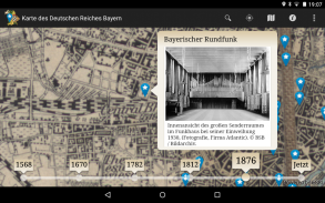
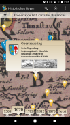
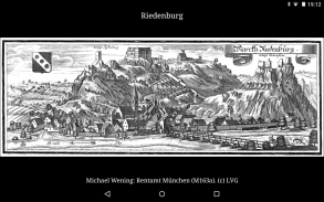
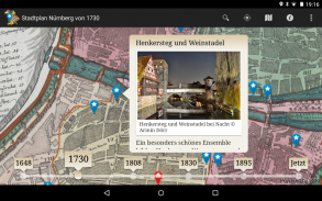
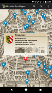
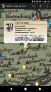
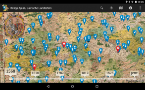
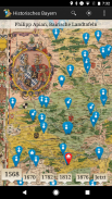
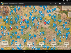
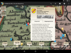
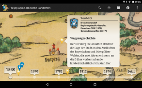
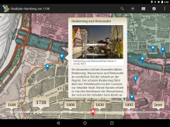
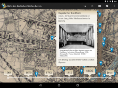
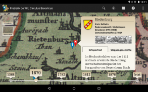
The location-based services app, "Bayern in historical maps" takes you on a fascinating journey to discover Bavaria cities, towns and monuments. Unique and rare historical maps of Bavaria owned by the Bavarian State Library, of the land boards Apian (1568) to "Topographical Atlas of the kingdoms of Bavaria" (1812-1867) may be considered in all details and explored interactively. Your current position as the viewer is displayed directly in the historical map, a timeline, you can navigate seamlessly between different map series. Diverse points-of-interest offer detailed representations to places, castles, monasteries and castles in the area of ​​your site, including 1,000 local historical views of Wening, Merian and Schedel. As a special highlight of Nuremberg offers a variety of multimedia-focused information about the Imperial Castle Town.

The Bavarian State Library is one of the world's largest and most significant research libraries. Their stocks are world famous and valuable works of the written cultural heritage of humanity, including a comprehensive collection of historical maps. The app "Bavaria in historical maps" is a site of the Bavarian State Library on the go and at home. On site you will find your current position in the selected historical map display, as well as interesting places and sites in their vicinity. You can go home in the high-resolution digitized historical maps to a virtual discovery tour through Bavaria. The offer is constantly expanding with new content.

Bayern in historischen Karten - Versi 1.6

(28-10-2022)
Versi lain
Apa yang baru- Jahreszahlen zu fränkischen Karten korrigiert- Aktualisierung externer Softwarekomponenten- Optimierung für neue Android Versionen- Performanceverbesserungen- Kleine Fehlerbehebungen

Belum ada ulasan atau penilaian! Untuk meninggalkan ulasan pertama,

-
0 Reviews
5
4
3
2
1

Bayern in historischen Karten - Informasi APK

Versi APK: 1.6Paket: de.bsb.android.historischesbayern
Kompatibilitas Android: 7.0+ (Nougat)
Pengembang:Bayerische StaatsbibliothekKebijakan Privasi:https://www.bsb-muenchen.de/impressen/mobile-app-bayern-in-historischen-karten-impressum-und-datenschutzerklaerung-androidIzin:6
Nama: Bayern in historischen KartenUkuran: 128 MBUnduhan: 2Versi : 1.6Tanggal Rilis: 2024-04-04 07:42:16Layar Minimal: SMALLCPU yang Didukung: armeabi-v7a, arm64-v8a
ID Paket: de.bsb.android.historischesbayernSHA1 Signature: 3F:24:35:80:1D:88:60:7E:3B:2B:55:85:18:9C:0A:CE:82:56:D2:60Pengembang (CN): Klaus CeynowaOrganisasi (O): Bayerische StaatsbibliothekLokal (L): MuenchenNegara (C): deProvinsi/Kota (ST): BayernID Paket: de.bsb.android.historischesbayernSHA1 Signature: 3F:24:35:80:1D:88:60:7E:3B:2B:55:85:18:9C:0A:CE:82:56:D2:60Pengembang (CN): Klaus CeynowaOrganisasi (O): Bayerische StaatsbibliothekLokal (L): MuenchenNegara (C): deProvinsi/Kota (ST): Bayern

Versi Terakhir dari Bayern in historischen Karten

1.6Trust Icon Versions
28/10/2022
2 unduhan128 MB Ukuran
Unduh

Versi lain

1.5.1Trust Icon Versions
25/7/2020
2 unduhan33.5 MB Ukuran
Unduh